
1944 Map of Wilmer
USGS Topo · Published 1944About this map
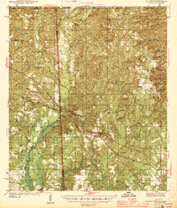
The Escatappa River defines the borderlands of the Alabama-Mississippi state line in this mid-century survey, winding through a landscape of creek-fed timberlands and rural crossroads. The settlement of Wilmer serves as a central hub, while the surrounding area is punctuated by community markers such as Moffet Sch and Macedonia Ch. To the southeast, the village of Semmes shows its early footprint near the Semmes Cem, situated before the significant suburban expansion of later decades. The drainage patterns of Puppy Creek and Big Creek illustrate the natural hydrology that dictated early road placement and settlement patterns. Notable landmarks like the Luce Fire Tower and Garrison Fire Tower highlight the importance of forest management in the Mobile County backcountry during the early 1940s.
Find a feature on this map
47 named features on this map. Tap any name to fly to it.
Don’t see what you’re looking for? This feature index may not catch every label — zoom into the map to look around manually.
Map Details
Editions of this 1944 Wilmer Map
2 editions found
Other maps of this area

1922 · Mobile
USGS Topo · 1:62,500

1940 · Mobile
USGS Topo · 1:62,500

1941 · Hurley
USGS Topo · 1:62,500

1941 · Vancleave
USGS Topo · 1:62,500

1941 · Creola
USGS Topo · 1:62,500

1941 · Lucedale
USGS Topo · 1:62,500

1942 · Kushla
USGS Topo · 1:31,680

1942 · Deer Park
USGS Topo · 1:62,500

1942 · Wilmer
USGS Topo · 1:62,500

1943 · Lucedale
USGS Topo · 1:62,500