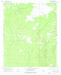
1960 Map of Wilmot NW
USGS Topo · Published 1977About this map
Carter Prairie and the low-lying wetlands of Ashley County define this 1960 landscape, where the drainage patterns of Chemin-a-Haut Creek and White Oak Creek dictate the layout of rural life. The settlement at Wallace in the northwest corner and several family cemeteries, including Cleveland Cem and Hogue Cem, reflect the scattered nature of the local community. A notable detail of this era is the presence of a Lookout Tower positioned near the center of the sheet, likely serving as a sentinel over the surrounding timber and agricultural lands. The eastern portion of the quadrangle is dominated by the Beech Creek Extra area, where Beech Creek Ch and its accompanying Beech Creek Cem suggest a focal point for residents living along the winding banks of Beech Creek and the Overflow Creek floodplains.
Find a feature on this map
17 named features on this map. Tap any name to fly to it.
Don’t see what you’re looking for? This feature index may not catch every label — zoom into the map to look around manually.
Map Details
Editions of this 1960 Wilmot NW Map
2 editions found
Other maps of this area

1935 · Mist
USGS Topo · 1:62,500

1935 · Wilmot
USGS Topo · 1:62,500

1952 · Fountain Hill
USGS Topo · 1:24,000

1953 · Greenwood
USGS Topo · 1:250,000

1956 · Greenwood
USGS Topo · 1:250,000

1960 · Snyder
USGS Topo · 1:24,000

1960 · Mist
USGS Topo · 1:62,500

1960 · Wilmot
USGS Topo · 1:62,500
1960 · Portland
USGS Topo · 1:24,000

1960 · Wilmot NW
USGS Topo · 1:24,000