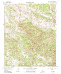
1966 Map of Wilson Corner
USGS Topo · Published 1985About this map
Wilson Corner serves as the primary named point of reference in this mid-1960s survey of the California back country within the Los Padres National Forest. The landscape is dominated by the rugged slopes of the La Panza Range, where a network of water sources like Ben Willow Spring, Deer Spring, and Milburn Spring provide vital points in a semi-arid terrain. The drainage patterns are clearly defined by the complex branching of Huerhuero Creek, including its East Branch and Middle Branch, which carve through the elevations.
Find a feature on this map
17 named features on this map. Tap any name to fly to it.
Don’t see what you’re looking for? This feature index may not catch every label — zoom into the map to look around manually.
Map Details
Editions of this 1966 Wilson Corner Map
2 editions found
Other maps of this area

1897 · San Luis Obispo
USGS Topo · 1:62,500

1900 · San Luis
USGS Topo · 1:125,000

1914 · Cholame
USGS Topo · 1:125,000

1915 · Cholame
USGS Topo · 1:125,000

1917 · Cholame
USGS Topo · 1:125,000

1919 · Paso Robles
USGS Topo · 1:62,500

1922 · Pozo
USGS Topo · 1:62,500

1942 · San Luis Obispo
USGS Topo · 1:62,500

1943 · Paso Robles
USGS Topo · 1:62,500

1943 · Commatti Canyon
USGS Topo · 1:31,680