
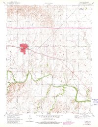
1956 Map of Wilson
USGS Topo · Published 1958About this map
Wilson serves as the central hub of this mid-century survey, positioned where the Union Pacific railroad cuts through the prairie landscape. The town's grid is detailed with municipal markers including City Hall, a post office, and a water tower, reflecting its role as a key transit and service point in western Ellsworth County. To the south, the meandering course of the Smoky Hill River creates a stark contrast with the upland townships of Highland, Noble, and Plymouth. This topography highlights the vital relationship between the river valley and the elevated agricultural plains above it. Local heritage is preserved through landmarks like Sunrise Sch and the distinct locations of Wilson Cem and the Old Wilson Cem, which offer significant value for genealogical research. The intersection of rail lines and drainage systems like Wilson Creek and Blood Creek illustrates the environmental factors that shaped early Kansas settlement patterns.
Find a feature on this map
17 named features on this map. Tap any name to fly to it.
Don’t see what you’re looking for? This feature index may not catch every label — zoom into the map to look around manually.
Map Details
Editions of this 1956 Wilson Map
2 editions found
Other maps of this area

1894 · Ellsworth
USGS Topo · 1:125,000

1896 · Russell
USGS Topo · 1:125,000

1955 · Great Bend
USGS Topo · 1:250,000

1956 · Dorrance
USGS Topo · 1:24,000

1957 · Great Bend
USGS Topo · 1:250,000

1957 · Holyrood NE
USGS Topo · 1:24,000

1957 · Black Wolf
USGS Topo · 1:24,000

1958 · Great Bend
USGS Topo · 1:250,000
1964 · Wilson NW
USGS Topo · 1:24,000
1964 · Holyrood NW
USGS Topo · 1:24,000