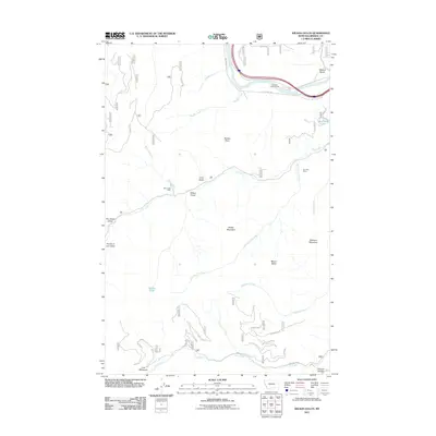
2011 Map of Wilson Gulch
USGS Topo · Published 2011About this map
Lost Meadows and the northern banks of the Clark Fork river define this Mineral County landscape as documented in 2011. The terrain is marked by significant elevation changes, from the heights of Sheep Mountain and Mount Baldy down to the deep drainages of Dry Fork Dry Creek and Thompson Creek. This survey captures the region's industrial and recreational profile through features like the Dry Fork Mine and Bear Creek Mine, alongside the Sloway Campground and Mud Lake. Navigation across this mountainous area is facilitated by established routes like Southside Rd and local tracks like Cheap Shot. This map serves as a valuable resource for understanding the modern distribution of resource extraction and public land use in western Montana.
Find a feature on this map
32 named features on this map. Tap any name to fly to it.
Don’t see what you’re looking for? This feature index may not catch every label — zoom into the map to look around manually.
Map Details
Editions of this 2011 Wilson Gulch Map
This is the sole edition of this map. No revisions or reprints were ever made.
Other maps of this area

1918 · St Regis
USGS Topo · 1:125,000

1919 · St. Regis
USGS Topo · 1:125,000

1956 · St Regis
USGS Topo · 1:62,500

1956 · Wallace
USGS Topo · 1:250,000

1957 · Illinois Peak
USGS Topo · 1:62,500

1959 · Plains
USGS Topo · 1:62,500

1960 · Wallace
USGS Topo · 1:250,000

1960 · Superior
USGS Topo · 1:62,500
1985 · Superior
USGS Topo · 1:24,000
1985 · Keystone Peak
USGS Topo · 1:24,000