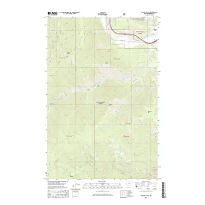
2017 Map of Wilson Gulch
USGS Topo · Published 2017About this map
The Clark Fork river carves through the northern reaches of this Mineral County landscape, accompanied by the historical alignment of Old US Hwy 10. This corridor, which includes Southside Rd, serves as the primary artery through the heavily forested terrain of the Lolo National Forest. The geography is defined by a series of significant peaks and drainages, including Mt Baldy, Sheep Mtn, and Blacktail Mtn, which overlook the complex network of gulches such as Wilson Gulch and Brown Gulch.
Find a feature on this map
52 named features on this map. Tap any name to fly to it.
Don’t see what you’re looking for? This feature index may not catch every label — zoom into the map to look around manually.
Map Details
Editions of this 2017 Wilson Gulch Map
This is the sole edition of this map. No revisions or reprints were ever made.
Other maps of this area

1918 · St Regis
USGS Topo · 1:125,000

1919 · St. Regis
USGS Topo · 1:125,000

1956 · St Regis
USGS Topo · 1:62,500

1956 · Wallace
USGS Topo · 1:250,000

1957 · Illinois Peak
USGS Topo · 1:62,500

1959 · Plains
USGS Topo · 1:62,500

1960 · Wallace
USGS Topo · 1:250,000

1960 · Superior
USGS Topo · 1:62,500
1985 · Superior
USGS Topo · 1:24,000
1985 · Keystone Peak
USGS Topo · 1:24,000