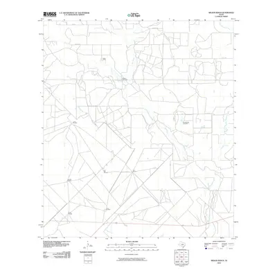
2010 Map of Wilson Ranch
USGS Topo · Published 2010About this map
Wilson Ranch sits at the heart of this rural Medina County landscape, where the management of water is central to the local economy. The terrain is defined by a network of seasonal drainages, including Squirrel Creek, Seco Creek, and Hondo Creek, which cut through the ranchland. Water infrastructure is prominently marked, including the Wilson Lake Dam and Eschenburg Lake Dam, alongside several family-named or utilitarian landmarks like the Javelin Windmill, Slaughter Windmill, and Briggs Windmill. These features reflect the long-standing ranching traditions of south-central Texas, where localized water sources were essential for livestock. A sparse network of roads, such as Wiemers Rd and Co Rd 1520, connects these remote outposts. The map documents a snapshot of land use where natural creek beds like Live Oak Creek and Tehuacana Creek dictate the placement of ranching infrastructure and local crossings.
Find a feature on this map
19 named features on this map. Tap any name to fly to it.
Don’t see what you’re looking for? This feature index may not catch every label — zoom into the map to look around manually.
Map Details
Editions of this 2010 Wilson Ranch Map
This is the sole edition of this map. No revisions or reprints were ever made.
Other maps of this area

1925 · Pearsall 1-b
USGS Topo · 1:48,000

1927 · Pearsall
USGS Topo · 1:62,500

1928 · Frio Town
USGS Topo · 1:62,500

1942 · Divot
USGS Topo · 1:62,500

1953 · Crystal City
USGS Topo · 1:250,000

1954 · San Antonio
USGS Topo · 1:250,000

1955 · Crystal City
USGS Topo · 1:250,000

1956 · Divot
USGS Topo · 1:62,500

1957 · San Antonio
USGS Topo · 1:250,000

1961 · Crystal City
USGS Topo · 1:250,000