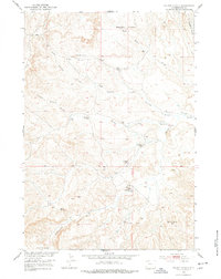
1951 Map of Wilson Spring
USGS Topo · Published 1978About this map
John Miller Ranch and a scattering of isolated homesteads define the remote character of this Park County landscape during the early 1950s. The map reveals a pattern of seasonal or specialized habitation through family-named sites like Webster Cabin, Joe Miller Cabin, and Nohr Cabin. These structures are positioned near critical water sources such as Baking Powder Springs and Wilson Spring, which were vital for survival and livestock in the arid terrain between Badger Basin and the Rimrock Basin.
Find a feature on this map
22 named features on this map. Tap any name to fly to it.
Don’t see what you’re looking for? This feature index may not catch every label — zoom into the map to look around manually.
Map Details
Editions of this 1951 Wilson Spring Map
2 editions found
Other maps of this area

1911 · Meeteetse
USGS Topo · 1:62,500

1911 · Oregon Basin
USGS Topo · 1:62,500

1913 · Oregon Basin
USGS Topo · 1:62,500

1913 · Meeteetse
USGS Topo · 1:62,500

1951 · Hillberry Rim
USGS Topo · 1:24,000

1951 · Gillies Draw
USGS Topo · 1:24,000

1951 · Tatman Mountain
USGS Topo · 1:24,000

1951 · Sheets Flat
USGS Topo · 1:24,000

1951 · Wilson Spring
USGS Topo · 1:24,000

1951 · Dead Indian Hill
USGS Topo · 1:24,000