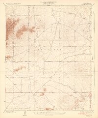
1935 Map of Wilsona
USGS Topo · Published 1935About this map
Antelope Valley dominates this 1930s landscape, showing a sparse desert settlement pattern characterized by long, straight thoroughfares like Avenue M and El Mirage Road. The small community of Wilsona sits at a crossroads, serving as a focal point for the homesteaders and ranchers who relied on the scattered water sources of the high desert. The topography is defined by the prominent Saddleback Butte rising sharply above the surrounding flats, while seasonal water features like Eller Slough and Moody Spr indicate the vital importance of drainage and natural springs in this arid environment. This survey, completed under Alfred Jones, County Surveyor, documents the early development of northern Los Angeles County before widespread modernization transformed the region's agricultural and residential layout.
Find a feature on this map
11 named features on this map. Tap any name to fly to it.
Don’t see what you’re looking for? This feature index may not catch every label — zoom into the map to look around manually.
Map Details
Editions of this 1935 Wilsona Map
3 editions found
Other maps of this area

1930 · Joshua
USGS Topo · 1:24,000

1930 · Lovejoy Springs
USGS Topo · 1:24,000

1930 · Black Butte
USGS Topo · 1:24,000

1930 · El Mirage
USGS Topo · 1:24,000

1930 · Llano
USGS Topo · 1:24,000

1930 · Angle
USGS Topo · 1:24,000

1930 · Wilsona
USGS Topo · 1:24,000

1931 · Adobe
USGS Topo · 1:24,000

1931 · Hi Vista
USGS Topo · 1:24,000

1932 · Angle
USGS Topo · 1:24,000