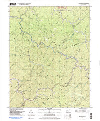
1996 Map of Wilsondale
USGS Topo · Published 2003About this map
Cabwaylingo State Forest dominates the high ground of the Tug Fork watershed, where the borders of Wayne, Mingo, and Lincoln counties meet. This 1990s survey documents a landscape defined by its deep hollows and narrow ridges, such as Tick Ridge and Perry Ridge, heavily marked by the region's energy economy. Dozens of gas and oil wells are scattered across the terrain, illustrating the persistent industrial footprint in these Appalachian valleys. Small communities like Wilsondale and Breeden serve as focal points along the winding path of Twelvepole Creek. The map is particularly valuable for genealogists, as it identifies numerous family burial grounds tucked away in the hills, including Stroud Cem, Stafford Cem, and Meade and Messer Cem. Cultural landmarks like the Lower Turkey Ch Sch further reflect the dispersed settlement pattern of this rural coal and timber country.
Find a feature on this map
79 named features on this map. Tap any name to fly to it.
Don’t see what you’re looking for? This feature index may not catch every label — zoom into the map to look around manually.
Map Details
Editions of this 1996 Wilsondale Map
This is the sole edition of this map. No revisions or reprints were ever made.
Other maps of this area

1887 · Warfield
USGS Topo · 1:125,000

1891 · Warfield
USGS Topo · 1:125,000

1892 · Huntington
USGS Topo · 1:125,000

1898 · Huntington
USGS Topo · 1:125,000

1902 · Midkiff
USGS Topo · 1:62,500

1907 · Midkiff
USGS Topo · 1:62,500

1909 · Wayne
USGS Topo · 1:62,500

1909 · Midkiff
USGS Topo · 1:62,500

1910 · Holden
USGS Topo · 1:48,000

1910 · Naugatuck
USGS Topo · 1:48,000