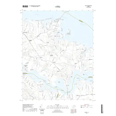
2019 Map of Wilton
USGS Topo · Published 2019About this map
Free Shade Corner and Harmony Village anchor this survey of the Virginia Middle Peninsula, where the land is deeply serrated by the tidal reaches of the Rappahannock River and Piankatank River. The landscape is defined by its relation to the water, featuring numerous points and necks such as Glebe Neck and Doctor Point, alongside interior water bodies like Barricks Millpond and Conrad Pond. This era of the late 2010s shows a mix of traditional rural settlements like Topping and Syringa alongside newer residential developments at Piankatank Shores. Significant infrastructure connects the peninsula to its neighbors, including the Norris Bridge crossing to Lancaster County and Twigg Bridge over the Piankatank River. Genealogists and local historians can find named landmarks ranging from Ebenezer Cem to the small community of Cobbs Creek, documenting the persistent settlement patterns of this tidewater region.
Find a feature on this map
60 named features on this map. Tap any name to fly to it.
Don’t see what you’re looking for? This feature index may not catch every label — zoom into the map to look around manually.
Map Details
Editions of this 2019 Wilton Map
This is the sole edition of this map. No revisions or reprints were ever made.
Other maps of this area

1906 · Williamsburg
USGS Topo · 1:62,500

1916 · Kilmarnock
USGS Topo · 1:48,000

1916 · Mathews
USGS Topo · 1:62,500

1917 · Urbanna
USGS Topo · 1:62,500

1917 · Kilmarnock
USGS Topo · 1:62,500

1917 · Mathews
USGS Topo · 1:62,500

1942 · Kilmarnock
USGS Topo · 1:62,500

1943 · Richmond
USGS Topo · 1:250,000
1946 · Urbanna
USGS Topo · 1:24,000

1948 · Ware Neck
USGS Topo · 1:24,000