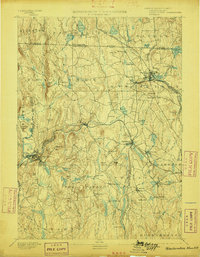
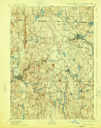
1894 Map of Winchendon
USGS Topo · Published 1898About this map
The Miller River and its numerous tributaries define the industrial and agricultural landscape of this Massachusetts and New Hampshire borderland in the late 19th century. This area is characterized by a dense network of water-powered hamlets and rail junctions, with the Fitchburg Railroad and Cheshire Railroad intersecting at major hubs like Winchendon. The terrain is punctuated by significant hills such as Mt. Pleasant and Tully Mtn., around which small settlements like South Royalston and Baldwinsville are tightly clustered. Notable for local historians are the numerous distinct village centers and specialized districts, including Brooks Village, Powers Mills, and Pequoig Station. The mapping captures a moment before modern consolidation, where isolated schools, churches like those at Church Hill, and small manufacturing sites like Furnace and Fryville were the primary engines of the local economy.
Find a feature on this map
103 named features on this map. Tap any name to fly to it.
Don’t see what you’re looking for? This feature index may not catch every label — zoom into the map to look around manually.
Map Details
Editions of this 1894 Winchendon Map
6 editions found

Other maps of this area

1885 · Worcester
USGS Topo · 1:62,500

1886 · Worcester
USGS Topo · 1:62,500

1887 · Warwick
USGS Topo · 1:62,500

1887 · Belchertown
USGS Topo · 1:62,500

1887 · Winchendon
USGS Topo · 1:62,500

1887 · Barre
USGS Topo · 1:62,500

1887 · Fitchburg
USGS Topo · 1:62,500

1889 · Fitchburg
USGS Topo · 1:62,500

1889 · Barre
USGS Topo · 1:62,500

1889 · Warwick
USGS Topo · 1:62,500