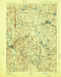
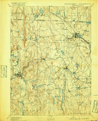
1894 Map of Winchendon
USGS Topo · Published 1924About this map
Industrial villages and hilltop settlements define the northern Worcester County landscape in the late 19th century. The Miller River and Otter River corridor serves as the primary artery for manufacturing and transit, with significant rail junctions at Winchendon and Baldwinville. These waterways supported numerous small centers like Waterville and Hydeville, while the higher ground nearby remained dominated by family-named landmarks such as Benjamin Hill and Jacob Hill.
Find a feature on this map
96 named features on this map. Tap any name to fly to it.
Don’t see what you’re looking for? This feature index may not catch every label — zoom into the map to look around manually.
Map Details
Editions of this 1894 Winchendon Map
6 editions found

Other maps of this area

1885 · Worcester
USGS Topo · 1:62,500

1886 · Worcester
USGS Topo · 1:62,500

1887 · Warwick
USGS Topo · 1:62,500

1887 · Belchertown
USGS Topo · 1:62,500

1887 · Winchendon
USGS Topo · 1:62,500

1887 · Barre
USGS Topo · 1:62,500

1887 · Fitchburg
USGS Topo · 1:62,500

1889 · Fitchburg
USGS Topo · 1:62,500

1889 · Barre
USGS Topo · 1:62,500

1889 · Warwick
USGS Topo · 1:62,500