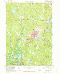
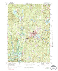
1971 Map of Winchendon
USGS Topo · Published 1973About this map
Winchendon serves as the industrial and civic anchor of this 1971 landscape, where the Millers River flows through a series of mill-related water bodies like Tannery Pond and Whitney Pond. The town's development is deeply intertwined with the Boston and Maine Railroad, which connects the main village to outlying settlements such as Waterville and Hydeville. To the north, the landscape crosses the State Line into New Hampshire, featuring Lake Monomonac and the remote Sip Pond. This survey captures the region just as local industry and transit patterns were stabilizing, noting significant municipal sites like the Town Hall and Murdock High Sch. The southern portion is dominated by public lands and flood control, including the Otter River State Forest and the Birch Hill Dam, which altered the natural course of the river near Beaman Brook.
Find a feature on this map
99 named features on this map. Tap any name to fly to it.
Don’t see what you’re looking for? This feature index may not catch every label — zoom into the map to look around manually.
Map Details
Editions of this 1971 Winchendon Map
5 editions found
Other maps of this area

1887 · Winchendon
USGS Topo · 1:62,500

1887 · Fitchburg
USGS Topo · 1:62,500

1889 · Fitchburg
USGS Topo · 1:62,500

1890 · Winchendon
USGS Topo · 1:62,500

1893 · Fitchburg
USGS Topo · 1:62,500

1894 · Winchendon
USGS Topo · 1:62,500

1898 · Monadnock
USGS Topo · 1:62,500

1900 · Peterboro
USGS Topo · 1:62,500

1931 · Fitchburg
USGS Topo · 1:48,000

1932 · Winchendon
USGS Topo · 1:48,000