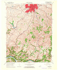
1965 Map of Winchester
USGS Topo · Published 1966About this map
Winchester serves as the focal point of this mid-century survey, showing the city's expansion through residential developments like Wesleyan Park, Colby Hills, and Hampton Manor. Educational and civic life is anchored by institutions such as Southeastern Christian College and the George Rogers Clark High Sch, while the bustling downtown core includes the Courthouse and local Library. The landscape to the south and west transitions into a network of rolling drainage basins, where Twomile Creek and Fourmile Creek flow toward the Kentucky River, which marks the boundary between Clark and Madison Counties.
Find a feature on this map
59 named features on this map. Tap any name to fly to it.
Don’t see what you’re looking for? This feature index may not catch every label — zoom into the map to look around manually.
Map Details
Editions of this 1965 Winchester Map
3 editions found
Other maps of this area

1892 · Richmond
USGS Topo · 1:125,000

1897 · Richmond
USGS Topo · 1:125,000

1927 · Lexington
USGS Topo · 1:48,000

1929 · Lexington
USGS Topo · 1:62,500

1952 · Union City
USGS Topo · 1:24,000

1952 · Palmer
USGS Topo · 1:24,000

1952 · Clintonville
USGS Topo · 1:24,000

1952 · Austerlitz
USGS Topo · 1:24,000

1952 · Ford
USGS Topo · 1:24,000

1952 · Winchester
USGS Topo · 1:24,000