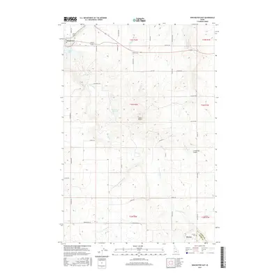
2017 Map of Winchester East
USGS Topo · Published 2017About this map
Winchester sits at the northwestern corner of this Idaho landscape, where the waters of Lapwai Lake transition into Lapwai Cr. The terrain is defined by a series of deep drainage networks, including Big Canyon Cr and Coldsprings Canyon, which carve through the high plateau. Significant local landmarks like Mason Butte rise above the surrounding fields, while the Mud Springs Reservoir provides a critical water source in the central sections. Toward the southeast, the settlement of Morrow and the nearby Morrow Cem mark the intersection of several rural routes. This 2017 survey by the U.S. Geological Survey documents a region where agricultural land use is tightly integrated with the natural topography, as seen in the grid of local roads like Talmaks Rd and Morrowtown Rd that follow the section lines across the Idaho and Lewis County border.
Find a feature on this map
41 named features on this map. Tap any name to fly to it.
Don’t see what you’re looking for? This feature index may not catch every label — zoom into the map to look around manually.
Map Details
Editions of this 2017 Winchester East Map
This is the sole edition of this map. No revisions or reprints were ever made.
Other maps of this area

1924 · Kamiah
USGS Topo · 1:125,000

1955 · Pullman
USGS Topo · 1:250,000

1958 · Pullman
USGS Topo · 1:250,000

1958 · Culdesac
USGS Topo · 1:62,500

1967 · Fletcher
USGS Topo · 1:24,000

1967 · Craigmont
USGS Topo · 1:24,000

1967 · Hoover Point
USGS Topo · 1:24,000

1967 · Westlake
USGS Topo · 1:24,000
1967 · Keuterville
USGS Topo · 1:24,000
1967 · Winchester East
USGS Topo · 1:24,000