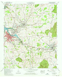
1971 Map of Winchester
USGS Topo · Published 1973About this map
Winchester and the neighboring industrial hubs of Decherd and Cowan anchor this 1971 survey of Franklin County. The landscape is defined by the recently established Tims Ford Lake, with the Tims Ford Reservation boundary following the winding contours of the Boiling Fork. This era shows significant suburban growth in developments like Bel-Aire Heights and Scenic Heights, yet the surrounding terrain maintains its agricultural and industrial roots.
Find a feature on this map
91 named features on this map. Tap any name to fly to it.
Don’t see what you’re looking for? This feature index may not catch every label — zoom into the map to look around manually.
Map Details
Editions of this 1971 Winchester Map
This is the sole edition of this map. No revisions or reprints were ever made.
Other maps of this area

1895 · Sewanee
USGS Topo · 1:125,000

1928 · Decherd
USGS Topo · 1:62,500

1936 · Sewanee
USGS Topo · 1:24,000

1936 · Alto
USGS Topo · 1:24,000

1936 · Sinking Cove
USGS Topo · 1:24,000

1936 · Beans Creek
USGS Topo · 1:24,000

1936 · Winchester
USGS Topo · 1:24,000

1936 · Belvidere
USGS Topo · 1:24,000

1936 · Pitcher Ridge
USGS Topo · 1:24,000

1936 · Camp Peay
USGS Topo · 1:24,000