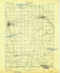
1918 Map of Winchester
USGS Topo · Published 1918About this map
The Winchester area in the late nineteen-teens shows a landscape defined by an intricate network of rail lines and rural schools. The Mississinewa River and the White River provide the primary drainage, while the Cleveland Cincinnati Chicago and St Louis RR and the Dayton and Union RR create a transit corridor through Union City. This survey captures the region before the consolidation of rural districts, preserving the locations of numerous small education centers such as the Sauerkraut School, Tampico School, and McKinley School.
Find a feature on this map
81 named features on this map. Tap any name to fly to it.
Don’t see what you’re looking for? This feature index may not catch every label — zoom into the map to look around manually.
Map Details
Editions of this 1918 Winchester Map
2 editions found
Other maps of this area

1908 · St. Henry
USGS Topo · 1:62,500

1915 · Fort Recovery
USGS Topo · 1:48,000

1915 · New Paris
USGS Topo · 1:48,000

1916 · Winchester
USGS Topo · 1:48,000

1918 · Winchester
USGS Topo · 1:62,500

1918 · Fort Recovery
USGS Topo · 1:62,500

1918 · New Paris
USGS Topo · 1:62,500

1943 · Winchester
USGS Topo · 1:62,500

1952 · Maxville
USGS Topo · 1:24,000

1953 · Cincinnati
USGS Topo · 1:250,000