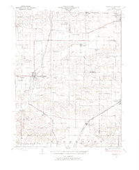
1924 Map of Winchester
USGS Topo · Published 1976About this map
Winchester and the surrounding Scott County landscape are defined here by a dense network of early 20th-century rural infrastructure. This 1920s survey reveals an era when country education was hyper-local, evidenced by nearly thirty named schoolhouses like Strawns Grove School, South College School, and Buckhorn School spaced just miles apart. The topography transitions from the bottoms of Mauvaise Terre Creek and Sandy Creek to the prominent heights of The Mound and Allison Mound. Transportation is dominated by the Chicago Burlington and Quincy and the Chicago and Alton railroads, which spurred the growth of settlements like Alsey and Manchester. A notable social landmark of the period is the Poor Farm located west of the Winchester town center, reflecting the county's early social welfare history.
Find a feature on this map
66 named features on this map. Tap any name to fly to it.
Don’t see what you’re looking for? This feature index may not catch every label — zoom into the map to look around manually.
Map Details
Editions of this 1924 Winchester Map
3 editions found
Other maps of this area

1924 · Winchester
USGS Topo · 1:48,000

1924 · Roodhouse
USGS Topo · 1:62,500

1924 · Griggsville
USGS Topo · 1:62,500

1926 · Griggsville
USGS Topo · 1:62,500

1926 · Winchester
USGS Topo · 1:62,500

1926 · Roodhouse
USGS Topo · 1:62,500

1928 · Meredosia
USGS Topo · 1:62,500

1929 · Arenzville
USGS Topo · 1:62,500

1930 · Pearl
USGS Topo · 1:62,500

1931 · Meredosia
USGS Topo · 1:62,500