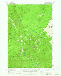
1957 Map of Wind River
USGS Topo · Published 1964About this map
Stabler and the surrounding timberlands of the Gifford Pinchot National Forest define this 1957 topographic study. The landscape is heavily influenced by the Wind River, which flows through a complex network of forest camps and research zones. Of particular importance to local history is the Wind River Experimental Forest and the Wind River Natural Area, where scientific forestry and conservation were established in the mid-20th century. The presence of the Fish Hatchery and Hemlock Ranger Sta reflects the administrative and economic focus of the era.
Find a feature on this map
92 named features on this map. Tap any name to fly to it.
Don’t see what you’re looking for? This feature index may not catch every label — zoom into the map to look around manually.
Map Details
Editions of this 1957 Wind River Map

Other maps of this area

1919 · Mount St Helens
USGS Topo · 1:125,000

1926 · Steamboat Mtn
USGS Topo · 1:125,000

1926 · Hood River
USGS Topo · 1:125,000

1929 · Hood River
USGS Topo · 1:125,000

1931 · Steamboat Mtn
USGS Topo · 1:125,000

1940 · Lookout Mtn
USGS Topo · 1:62,500

1948 · Vancouver
USGS Topo · 1:250,000

1950 · Vancouver
USGS Topo · 1:250,000

1950 · Vancouver
USGS Topo · 1:250,000

1950 · Yakima
USGS Topo · 1:250,000