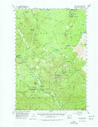
1957 Map of Wind River
USGS Topo · Published 1977About this map
Gifford Pinchot National Forest defines this mid-century landscape in Skamania County, where the Wind River cuts through a densely wooded terrain of volcanic buttes and experimental forestry. The map documents the extensive infrastructure of the Wind River Experimental Forest and the Wind River Natural Area, including the Hemlock Ranger Sta and a dedicated Fish Hatchery. Human settlement is concentrated at Stabler and Warren Gap, while the surrounding wilderness is marked by numerous recreation sites like Government Mineral Springs and Little Soda Springs Forest Camp. The geography is characterized by prominent peaks like Bunker Hill and Big Butte, alongside unique geological features including Lava Caves and the Lava Bed to the east. This survey captures a moment of intensive federal forest management, showing a network of fire lookouts and forest camps before later wilderness designations altered the management of these lands.
Find a feature on this map
96 named features on this map. Tap any name to fly to it.
Don’t see what you’re looking for? This feature index may not catch every label — zoom into the map to look around manually.
Map Details
Editions of this 1957 Wind River Map

Other maps of this area

1919 · Mount St Helens
USGS Topo · 1:125,000

1926 · Steamboat Mtn
USGS Topo · 1:125,000

1926 · Hood River
USGS Topo · 1:125,000

1929 · Hood River
USGS Topo · 1:125,000

1931 · Steamboat Mtn
USGS Topo · 1:125,000

1940 · Lookout Mtn
USGS Topo · 1:62,500

1948 · Vancouver
USGS Topo · 1:250,000

1950 · Vancouver
USGS Topo · 1:250,000

1950 · Vancouver
USGS Topo · 1:250,000

1950 · Yakima
USGS Topo · 1:250,000