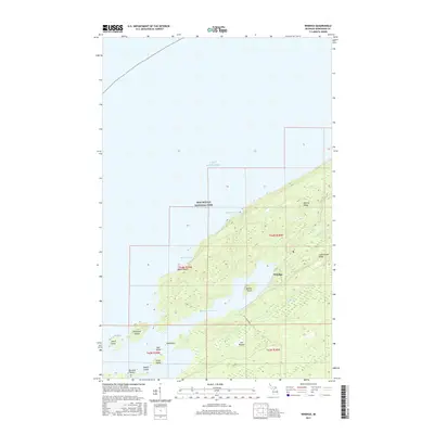
2017 Map of Windigo
USGS Topo · Published 2017About this map
Windigo serves as the primary outpost at the southwestern end of Isle Royale National Park, where the island’s wilderness meets the expansive waters of Lake Superior. The landscape is defined by the parallel elevations of Minong Ridge and Greenstone Ridge, which channel waterways like Washington Creek and Grace Creek toward the sheltered deep-water inlets. This 2017 survey shows the intricate coastal geography of Washington Harbor and Grace Harbor, protected by a chain of smaller landmasses including Beaver Island, Thompson Island, and Johns Island. The map details important shore access points such as Agate Beach and Huginnin Cove, illustrating the intersection of navigation and terrain that has shaped this remote Michigan archipelago. The boundary markings for t64n r39w and surrounding townships reflect the underlying public land survey system that partitions this island territory within Keweenaw County.
Find a feature on this map
26 named features on this map. Tap any name to fly to it.
Don’t see what you’re looking for? This feature index may not catch every label — zoom into the map to look around manually.
Map Details
Editions of this 2017 Windigo Map
This is the sole edition of this map. No revisions or reprints were ever made.
Other maps of this area

1958 · Hancock
USGS Topo · 1:250,000

1959 · Fort William
USGS Topo · 1:250,000

1960 · Hancock
USGS Topo · 1:250,000

1961 · Hancock
USGS Topo · 1:250,000

1966 · Hancock
USGS Topo · 1:250,000

1968 · Fort William
USGS Topo · 1:250,000

1985 · Pigeon Point
USGS Topo · 1:100,000

1985 · Grand Portage
USGS Topo · 1:100,000
1985 · Feldtmann Ridge
USGS Topo · 1:24,000
1985 · Feldtmann Lake
USGS Topo · 1:24,000