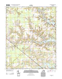
2013 Map of Windsor
USGS Topo · Published 2013About this map
Windsor anchors the western edge of this landscape, where the intersection of Courthouse Hwy and Windsor Blvd forms a primary transportation hub. Moving east, the terrain transitions into a complex network of waterways and wetlands, including Pope Swamp and Carbell Swamp. The region's history of water management and local industry is evident in the numerous millponds such as Murphys Millpond, Prudens Millpond, and Br and Joyner Millpond, which dot the drainage basins feeding into larger reservoirs like Lake Prince and Lake Cohoon. Small residential developments and named crossroads like Indika, Myrtle, and Acorn Acres are scattered throughout, while Garner Airport provides a specialized landmark north of the main thoroughfares. In the southeast, the Kings Fork area is marked by Providence Church, reflecting the community foundations of this part of Isle of Wight County.
Find a feature on this map
87 named features on this map. Tap any name to fly to it.
Don’t see what you’re looking for? This feature index may not catch every label — zoom into the map to look around manually.
Map Details
Editions of this 2013 Windsor Map
This is the sole edition of this map. No revisions or reprints were ever made.
Other maps of this area

1919 · Smithfield
USGS Topo · 1:62,500

1919 · Suffolk
USGS Topo · 1:62,500

1920 · Holland
USGS Topo · 1:62,500

1920 · Ivor
USGS Topo · 1:62,500

1943 · Holland
USGS Topo · 1:62,500

1944 · Windsor
USGS Topo · 1:31,680

1944 · Smithfield
USGS Topo · 1:24,000

1944 · Raynor
USGS Topo · 1:24,000

1944 · Zuni
USGS Topo · 1:24,000

1945 · Zuni
USGS Topo · 1:31,680