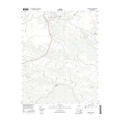
2016 Map of Windsor South
USGS Topo · Published 2016About this map
Windsor sits at the northern edge of this map, serving as a gateway to the expansive wetlands and river systems that define the Bertie County landscape. The southern reaches are dominated by the Roanoke River, which forms the boundary with Martin County and encircles the large, marshy expanse of Conine Island. This region is characterized by an intricate network of waterways including Mill Swamp, Roquist Cr, and the Cashie River, illustrating the historical importance of these riverine corridors for transport and drainage. Inland, the map reveals a pattern of rural connectivity with routes like Tarheel Rd and Cedar Landing Rd linking isolated homesteads and small communities such as Ellis Store. Genealogists may find interest in the location of Hillcrest Cem near the town center, while topographical features like White Banks along the river signify the distinct landforms of the North Carolina Coastal Plain.
Find a feature on this map
45 named features on this map. Tap any name to fly to it.
Don’t see what you’re looking for? This feature index may not catch every label — zoom into the map to look around manually.
Map Details
Editions of this 2016 Windsor South Map
This is the sole edition of this map. No revisions or reprints were ever made.
Other maps of this area

1901 · Williamston
USGS Topo · 1:62,500

1902 · Williamston
USGS Topo · 1:62,500

1943 · Plymouth
USGS Topo · 1:125,000

1953 · Norfolk
USGS Topo · 1:250,000

1953 · Rocky Mount
USGS Topo · 1:250,000

1954 · Rocky Mount
USGS Topo · 1:250,000

1972 · Republican
USGS Topo · 1:24,000
1978 · Jamesville
USGS Topo · 1:24,000

1978 · Windsor South
USGS Topo · 1:24,000
1979 · Plymouth West
USGS Topo · 1:24,000