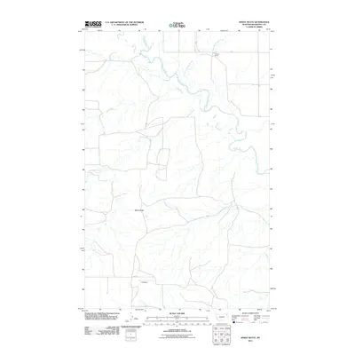
2011 Map of Windy Butte
USGS Topo · Published 2011About this map
Poplar River meanders across this landscape in eastern Montana, joined by a network of drainage systems including Give Out Morgan Creek and Sage Creek. The terrain is defined by low-lying plains punctuated by the namesake Windy Butte and the winding course of Assiniboine Creek. Human presence is sparse in this 2011 survey, marked by isolated points of interest like the Cuskers House near the northern boundary and the private landing strip at J B Airport in the south. The road network is primarily composed of unnamed local routes, with 2042 Rd providing a rare named connection through the open country. This record of the Poplar District reflects the area's continued use for grazing and transport long after the initial settlement era.
Find a feature on this map
9 named features on this map. Tap any name to fly to it.
Don’t see what you’re looking for? This feature index may not catch every label — zoom into the map to look around manually.
Map Details
Editions of this 2011 Windy Butte Map
This is the sole edition of this map. No revisions or reprints were ever made.
Other maps of this area

1910 · Cuskers
USGS Topo · 1:62,500

1912 · Hay Creek
USGS Topo · 1:62,500

1915 · Cuskers
USGS Topo · 1:62,500

1954 · Wolf Point
USGS Topo · 1:250,000

1958 · Wolf Point
USGS Topo · 1:250,000

1973 · Bredette
USGS Topo · 1:24,000

1973 · Nielsen Coulee
USGS Topo · 1:24,000

1973 · Pleasant Prairie SW
USGS Topo · 1:24,000
1983 · Hay Creek NW
USGS Topo · 1:24,000
1983 · Long Creek West
USGS Topo · 1:24,000