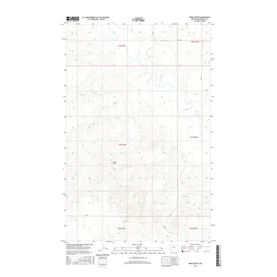
2017 Map of Windy Butte
USGS Topo · Published 2017About this map
Poplar River winds through this Roosevelt County landscape, carving a wide valley floor as it moves southeast toward the Missouri River. The terrain is defined by complex drainage networks, where Give Out Morgan Cr, Sage Cr, and Assiniboine Cr converge towards the primary waterway. Rising above the surrounding coulees, Windy Butte serves as the most prominent topographic landmark in the area. This 2017 study illustrates the sparse, high-plains character of the region, where movement is dictated by the river's path and a grid of rural routes such as RD 1058 and 2042 RD. The map documents the enduring cattle-country land divisions of the Public Land Survey System, tracing the township lines across the open Montana prairie.
Find a feature on this map
17 named features on this map. Tap any name to fly to it.
Don’t see what you’re looking for? This feature index may not catch every label — zoom into the map to look around manually.
Map Details
Editions of this 2017 Windy Butte Map
This is the sole edition of this map. No revisions or reprints were ever made.
Other maps of this area

1910 · Cuskers
USGS Topo · 1:62,500

1912 · Hay Creek
USGS Topo · 1:62,500

1915 · Cuskers
USGS Topo · 1:62,500

1954 · Wolf Point
USGS Topo · 1:250,000

1958 · Wolf Point
USGS Topo · 1:250,000

1973 · Bredette
USGS Topo · 1:24,000

1973 · Nielsen Coulee
USGS Topo · 1:24,000

1973 · Pleasant Prairie SW
USGS Topo · 1:24,000
1983 · Hay Creek NW
USGS Topo · 1:24,000
1983 · Long Creek West
USGS Topo · 1:24,000