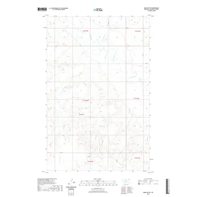
2020 Map of Windy Butte
USGS Topo · Published 2020About this map
Windy Butte rises above the vast drainage system of the Poplar River in this survey of northeastern Montana. The landscape is defined by its seasonal watercourses, including Sage Cr and Assiniboine Cr, which carve through the high plains of the Poplar District. This topography reveals a largely undeveloped expanse within the Fort Peck Indian Reservation, where the drainage patterns of Give Out Morgan Cr and Long Cr dictate the layout of rural access roads like 2042 RD. The survey illustrates the intersection of Public Land Survey System townships such as t31n r49e and t31n r50e, providing a clear view of the territorial organization in this part of Roosevelt County. The lack of dense settlement highlights the enduring rural character of the Missouri River plateau as it appeared in the early twenty-first century.
Find a feature on this map
17 named features on this map. Tap any name to fly to it.
Don’t see what you’re looking for? This feature index may not catch every label — zoom into the map to look around manually.
Map Details
Editions of this 2020 Windy Butte Map
This is the sole edition of this map. No revisions or reprints were ever made.
Other maps of this area

1910 · Cuskers
USGS Topo · 1:62,500

1912 · Hay Creek
USGS Topo · 1:62,500

1915 · Cuskers
USGS Topo · 1:62,500

1954 · Wolf Point
USGS Topo · 1:250,000

1958 · Wolf Point
USGS Topo · 1:250,000

1973 · Bredette
USGS Topo · 1:24,000

1973 · Nielsen Coulee
USGS Topo · 1:24,000

1973 · Pleasant Prairie SW
USGS Topo · 1:24,000
1983 · Hay Creek NW
USGS Topo · 1:24,000
1983 · Long Creek West
USGS Topo · 1:24,000