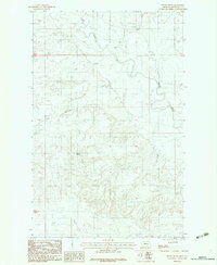
1983 Map of Windy Butte
USGS Topo · Published 1983About this map
Windy Butte rises above a landscape defined by the branching waterways of the Fort Peck Indian Reservation during the late 1970s and early 1980s. The Poplar River winds through the northern and eastern portions of the quadrangle, serving as the primary drainage for numerous seasonal tributaries including Morgan Creek, Glue Creek, and Assiniboine Creek. This rural section of Roosevelt County shows a sparse pattern of land use typical of the High Plains, where the most prominent man-made landmarks are Grain Bins located near Sage Creek. The network of drainages such as Long Creek indicates a complex erosion pattern across the prairie, while the presence of agricultural storage facilities highlights the area's deep-rooted reliance on dryland farming and ranching.
Find a feature on this map
11 named features on this map. Tap any name to fly to it.
Don’t see what you’re looking for? This feature index may not catch every label — zoom into the map to look around manually.
Map Details
Editions of this 1983 Windy Butte Map
This is the sole edition of this map. No revisions or reprints were ever made.
Other maps of this area

1910 · Cuskers
USGS Topo · 1:62,500

1912 · Hay Creek
USGS Topo · 1:62,500

1915 · Cuskers
USGS Topo · 1:62,500

1954 · Wolf Point
USGS Topo · 1:250,000

1958 · Wolf Point
USGS Topo · 1:250,000

1973 · Bredette
USGS Topo · 1:24,000

1973 · Nielsen Coulee
USGS Topo · 1:24,000

1973 · Pleasant Prairie SW
USGS Topo · 1:24,000
1983 · Hay Creek NW
USGS Topo · 1:24,000
1983 · Long Creek West
USGS Topo · 1:24,000