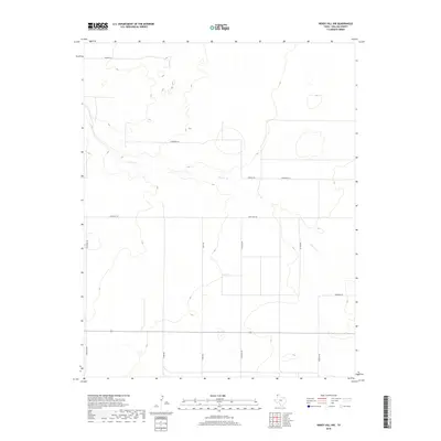
2019 Map of Windy Hill NW
USGS Topo · Published 2019About this map
Carrizo Cr winds through this section of the Texas Panhandle, defining the subtle drainage patterns of the high plains landscape in Dallam County. The area is characterized by a sparse network of section-line roads and family-named thoroughfares that reflect the ranching and agricultural heritage of the region. Local travel and land access are facilitated by routes such as Ranch Rd 102, Lewis Rd, and Nichols Rd, which segment the terrain into large parcels. This 2019 survey documents the modern layout of rural properties, where lanes like Higgins Ln and Lamberger Ln provide entry to isolated homesteads or agricultural operations far from established town centers. The land maintains a distinct openness, with development largely confined to these named corridors and the primary arterial road crossing the lower half of the quadrangle.
Find a feature on this map
12 named features on this map. Tap any name to fly to it.
Don’t see what you’re looking for? This feature index may not catch every label — zoom into the map to look around manually.
Map Details
Editions of this 2019 Windy Hill NW Map
This is the sole edition of this map. No revisions or reprints were ever made.
Other maps of this area

1954 · Dalhart
USGS Topo · 1:250,000

1958 · Dalhart
USGS Topo · 1:250,000

1962 · Dalhart
USGS Topo · 1:250,000

1970 · Texline South
USGS Topo · 1:24,000

1970 · Sedan SE
USGS Topo · 1:24,000

1970 · Sedan NE
USGS Topo · 1:24,000

1973 · Wharton Ranch
USGS Topo · 1:24,000

1973 · Corlena
USGS Topo · 1:24,000

1973 · Perico
USGS Topo · 1:24,000
1973 · Windy Hill
USGS Topo · 1:24,000