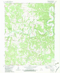
1982 Map of Windyville
USGS Topo · Published 1983About this map
The Niangua River carves a winding path through this portion of Dallas County, creating a landscape defined by dramatic river bluffs such as Kehler Bluff, Hildebrand Bluff, and Bramwell Bluff. The settlement of Windyville serves as a central point, supported by community institutions like the Windyville Church and Hildebrand Church. Genealogists will find a high density of family burial sites scattered throughout the rural landscape, including the Scrivner, Hildebrand, and Phillips cemeteries, providing a clear picture of local family lineage in the early 1980s. Recreation and conservation are evident in the western reaches at Hackler Ford State Forest and along the river at the Moon Valley Access Point. The map also documents essential infrastructure such as a significant pipeline corridor crossing the southern half of the quadrangle near Cedar Ridge.
Find a feature on this map
49 named features on this map. Tap any name to fly to it.
Don’t see what you’re looking for? This feature index may not catch every label — zoom into the map to look around manually.
Map Details
Editions of this 1982 Windyville Map
This is the sole edition of this map. No revisions or reprints were ever made.
Other maps of this area

1884 · Bolivar
USGS Topo · 1:125,000

1892 · Bolivar
USGS Topo · 1:125,000

1934 · Macks Creek
USGS Topo · 1:48,000

1939 · Macks Creek
USGS Topo · 1:62,500

1939 · Long Lane
USGS Topo · 1:62,500

1942 · Long Lane
USGS Topo · 1:62,500

1954 · Springfield
USGS Topo · 1:250,000

1958 · Springfield
USGS Topo · 1:250,000

1959 · Springfield
USGS Topo · 1:250,000
1960 · Tunas
USGS Topo · 1:24,000