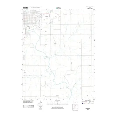
2010 Map of Winfield
USGS Topo · Published 2010About this map
Winfield serves as the focal point of this regional study, situated where Timber Creek meets the meandering Walnut River. The map illustrates a landscape shaped by petroleum extraction and agriculture, with numerous resource sites such as the Winfield Oil Field, Winfield South Oil Field, and Seacat Oil Field dotting the countryside. Beyond the residential grid of the city, the topography becomes more varied, featuring the distinctive Cup and Saucer Hills and the southern descent into Baugh Canyon.
Find a feature on this map
59 named features on this map. Tap any name to fly to it.
Don’t see what you’re looking for? This feature index may not catch every label — zoom into the map to look around manually.
Map Details
Editions of this 2010 Winfield Map
This is the sole edition of this map. No revisions or reprints were ever made.
Other maps of this area

1889 · Burden
USGS Topo · 1:125,000

1890 · Wellington
USGS Topo · 1:125,000

1955 · Wichita
USGS Topo · 1:250,000

1958 · Wichita
USGS Topo · 1:250,000

1964 · Burden
USGS Topo · 1:24,000
1964 · Maple City
USGS Topo · 1:24,000

1965 · Silverdale
USGS Topo · 1:24,000

1965 · Arkansas City
USGS Topo · 1:24,000

1965 · Eaton
USGS Topo · 1:24,000

1965 · Winfield
USGS Topo · 1:24,000