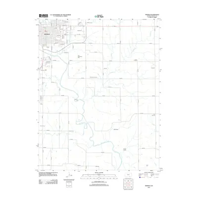
2012 Map of Winfield
USGS Topo · Published 2012About this map
The Walnut River meanders southward through the heart of Cowley County, anchoring a landscape where academic life and petroleum extraction coexist. The city of Winfield dominates the northwestern corner of the sheet, centered around the campus of Southwestern Coll and a grid of historic residential avenues like Warren Ave and Central Ave. Beyond the city limits, the terrain transitions into a productive resource landscape, defined by active energy operations at the Winfield Oil Field and the Seacat Oil Field.
Find a feature on this map
51 named features on this map. Tap any name to fly to it.
Don’t see what you’re looking for? This feature index may not catch every label — zoom into the map to look around manually.
Map Details
Editions of this 2012 Winfield Map
This is the sole edition of this map. No revisions or reprints were ever made.
Other maps of this area

1889 · Burden
USGS Topo · 1:125,000

1890 · Wellington
USGS Topo · 1:125,000

1955 · Wichita
USGS Topo · 1:250,000

1958 · Wichita
USGS Topo · 1:250,000

1964 · Burden
USGS Topo · 1:24,000
1964 · Maple City
USGS Topo · 1:24,000

1965 · Silverdale
USGS Topo · 1:24,000

1965 · Arkansas City
USGS Topo · 1:24,000

1965 · Eaton
USGS Topo · 1:24,000

1965 · Winfield
USGS Topo · 1:24,000