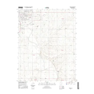
2015 Map of Winfield
USGS Topo · Published 2015About this map
The Winfield city center sits at a bend in the Walnut River, where a dense grid of streets like Manning St and College St meets the campus of Southwestern Coll. Outside the municipal limits, the landscape transitions into the distinctive topography of the Cup and Saucer Hills and the carved depressions of Baugh Canyon and Redd Valley. This 2015 survey reveals a significant concentration of rural burial sites and institutional history, including the Cowley County Poor Farm Cem and several community grounds like Saint Mary's Cem and Fairview - Griffith Cem. The Bnsf RR cuts through the western edge of the town, illustrating the continued reliance on rail infrastructure for the transport of goods across the Flint Hills region. Numerous small waterways, such as Black Crook Cr and W Badger Cr, snake through the surrounding agricultural sections.
Find a feature on this map
108 named features on this map. Tap any name to fly to it.
Don’t see what you’re looking for? This feature index may not catch every label — zoom into the map to look around manually.
Map Details
Editions of this 2015 Winfield Map
This is the sole edition of this map. No revisions or reprints were ever made.
Other maps of this area

1889 · Burden
USGS Topo · 1:125,000

1890 · Wellington
USGS Topo · 1:125,000

1955 · Wichita
USGS Topo · 1:250,000

1958 · Wichita
USGS Topo · 1:250,000

1964 · Burden
USGS Topo · 1:24,000
1964 · Maple City
USGS Topo · 1:24,000

1965 · Silverdale
USGS Topo · 1:24,000

1965 · Arkansas City
USGS Topo · 1:24,000

1965 · Eaton
USGS Topo · 1:24,000

1965 · Winfield
USGS Topo · 1:24,000