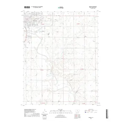
2018 Map of Winfield
USGS Topo · Published 2018About this map
The Walnut River meanders through the heart of this landscape, its path defining the transition between the urban grid of Winfield and the undulating plains of Cowley County. To the southeast of the city center, the distinct topography of the Cup and Saucer Hills rises above the river valley, providing a localized landmark among the agricultural sections. The map reveals a high density of small burial grounds that reflect the county's early settlement patterns, including the Cowley County Poor Farm Cem and Saint Mary's Cem near the town limits, while more remote sites like Rose Valley Cem and Liberty Cem mark the rural landscape to the south. Further east, the terrain becomes increasingly dissected by drainage networks such as Big Badger Cr and Redd Valley, showing the complex watershed that feeds into the river system.
Find a feature on this map
104 named features on this map. Tap any name to fly to it.
Don’t see what you’re looking for? This feature index may not catch every label — zoom into the map to look around manually.
Map Details
Editions of this 2018 Winfield Map
This is the sole edition of this map. No revisions or reprints were ever made.
Other maps of this area

1889 · Burden
USGS Topo · 1:125,000

1890 · Wellington
USGS Topo · 1:125,000

1955 · Wichita
USGS Topo · 1:250,000

1958 · Wichita
USGS Topo · 1:250,000

1964 · Burden
USGS Topo · 1:24,000
1964 · Maple City
USGS Topo · 1:24,000

1965 · Silverdale
USGS Topo · 1:24,000

1965 · Arkansas City
USGS Topo · 1:24,000

1965 · Eaton
USGS Topo · 1:24,000

1965 · Winfield
USGS Topo · 1:24,000