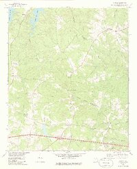
1979 Map of Winfield
USGS Topo · Published 1985About this map
Germany Creek and its many branches like Little Germany Creek and Shiloh Creek carve through the landscape along the Columbia and McDuffie county border. This area is characterized by a high concentration of country churches and rural crossroads that anchor local history, from the northern settlement of Winfield near Sharon Ch to the southern reaches near Jones Chapel. The map documents the shoreline of Clarks Hill Lake in the northwest, where Raysville sits as a key point of access. Inland, the distribution of names like Ansley Mill, Scuffletown, and Stones Crossroads reflects an agricultural and community network that predates modern development, while the White Oak Campground near White Oak Ch points toward the region's recreational and congregational life.
Find a feature on this map
29 named features on this map. Tap any name to fly to it.
Don’t see what you’re looking for? This feature index may not catch every label — zoom into the map to look around manually.
Map Details
Editions of this 1979 Winfield Map
This is the sole edition of this map. No revisions or reprints were ever made.
Other maps of this area

1892 · Mc Cormick
USGS Topo · 1:125,000

1906 · Crawfordville
USGS Topo · 1:125,000

1912 · Mc Cormick
USGS Topo · 1:125,000

1921 · Appling
USGS Topo · 1:62,500

1922 · Harlem
USGS Topo · 1:62,500

1943 · Appling
USGS Topo · 1:62,500

1948 · Harlem
USGS Topo · 1:62,500

1948 · Harlem
USGS Topo · 1:24,000

1948 · Thomson East
USGS Topo · 1:24,000

1950 · Dearing
USGS Topo · 1:24,000