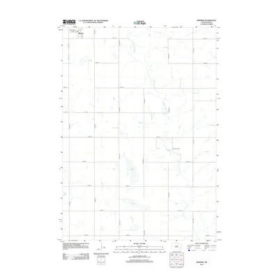
2012 Map of Winfred
USGS Topo · Published 2012About this map
Winfred anchors the northwest corner of this Lake County landscape, where the town's grid of residential streets like Central Ave and Lake St meets the expansive section lines of the surrounding prairie. The terrain is defined by the winding course of the E Fork Vermillion River, which meanders southward toward the Graceville Colony, an intentional community settlement typical of the region's agricultural heritage. This 2012 survey illustrates a classic South Dakota township structure, where the natural hydrology of water bodies like Lake Henry and Lake George interrupts the rigid square-mile grid of the section roads. These lakes and the river fork provide the primary relief in an otherwise strictly organized rural landscape dedicated to industrial-scale farming.
Find a feature on this map
23 named features on this map. Tap any name to fly to it.
Don’t see what you’re looking for? This feature index may not catch every label — zoom into the map to look around manually.
Map Details
Editions of this 2012 Winfred Map
This is the sole edition of this map. No revisions or reprints were ever made.
Other maps of this area

1953 · Watertown
USGS Topo · 1:250,000

1955 · Sioux Falls
USGS Topo · 1:250,000

1958 · Sioux Falls
USGS Topo · 1:250,000

1958 · Watertown
USGS Topo · 1:250,000

1968 · Oldham SW
USGS Topo · 1:24,000

1968 · Ramona
USGS Topo · 1:24,000

1968 · Lake Madison SW
USGS Topo · 1:24,000

1968 · Lake Herman
USGS Topo · 1:24,000

1968 · Oldham SE
USGS Topo · 1:24,000
1971 · Winfred
USGS Topo · 1:24,000
Featured Places
- Winfred, SD
- Clarno Township, SD
- Vermillion Township, SD
- Gracevale Hutterite Colony, SD
- Winfred Township, SD