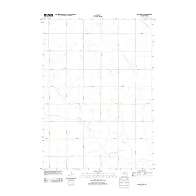
2012 Map of Winfred SE
USGS Topo · Published 2012About this map
Salem Lutheran Cem serves as a primary historical landmark in this agrarian landscape of McCook County, situated along the section lines that define the region's development. The terrain is characterized by a high concentration of prairie potholes and small depressions, typical of the glaciated plains of South Dakota. The drainage system is anchored by the meandering paths of the Little Vermillion River and the E Fork Vermillion River, which cut through the strictly rectilinear grid of rural roads such as 245th St and 444th Ave. This survey illustrates the persistent township-and-range settlement pattern, where small family farms are linked by a network of numbered avenues and streets, maintaining the spatial organization established over a century prior.
Find a feature on this map
17 named features on this map. Tap any name to fly to it.
Don’t see what you’re looking for? This feature index may not catch every label — zoom into the map to look around manually.
Map Details
Editions of this 2012 Winfred SE Map
This is the sole edition of this map. No revisions or reprints were ever made.
Other maps of this area

1955 · Sioux Falls
USGS Topo · 1:250,000

1958 · Sioux Falls
USGS Topo · 1:250,000

1964 · Montrose
USGS Topo · 1:24,000

1964 · Salem NE
USGS Topo · 1:24,000

1964 · Salem
USGS Topo · 1:24,000

1968 · Lake Madison SW
USGS Topo · 1:24,000

1968 · Lake Herman
USGS Topo · 1:24,000
1971 · Winfred
USGS Topo · 1:24,000
1971 · Canova East
USGS Topo · 1:24,000

1971 · Unityville
USGS Topo · 1:24,000
Featured Places
- Richland Township, SD
- Sun Prairie Township, SD
- Clarno Township, SD
- Vermillion Township, SD
- Salem Township, SD