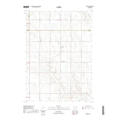
2017 Map of Winfred SE
USGS Topo · Published 2017About this map
The glacial upland known as the Coteau des Prairies defines the landscape of this eastern South Dakota region, where the headwaters of the Vermillion River system begin their southward journey. This survey reveals a purely rural section of McCook, Lake, and Miner counties, organized by a rigid grid of section-line roads like 245th St and Co Hwy 58. Genealogists will find the Salem Lutheran Cem as a primary landmark for the early Norwegian and German families who settled these townships. The hydrology is dominated by the meandering paths of the Little Vermillion River and the E Fork Vermillion River, which cut across the high prairie. The map provides a clear record of land use and drainage patterns in a territory where the natural prairie was systematically converted into a productive agricultural grid.
Find a feature on this map
19 named features on this map. Tap any name to fly to it.
Don’t see what you’re looking for? This feature index may not catch every label — zoom into the map to look around manually.
Map Details
Editions of this 2017 Winfred SE Map
This is the sole edition of this map. No revisions or reprints were ever made.
Other maps of this area

1955 · Sioux Falls
USGS Topo · 1:250,000

1958 · Sioux Falls
USGS Topo · 1:250,000

1964 · Montrose
USGS Topo · 1:24,000

1964 · Salem NE
USGS Topo · 1:24,000

1964 · Salem
USGS Topo · 1:24,000

1968 · Lake Madison SW
USGS Topo · 1:24,000

1968 · Lake Herman
USGS Topo · 1:24,000
1971 · Winfred
USGS Topo · 1:24,000
1971 · Canova East
USGS Topo · 1:24,000

1971 · Unityville
USGS Topo · 1:24,000
Featured Places
- Richland Township, SD
- Sun Prairie Township, SD
- Clarno Township, SD
- Vermillion Township, SD
- Salem Township, SD