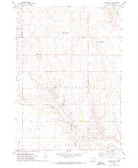
1971 Map of Winfred SE
USGS Topo · Published 1974About this map
Little Vermillion River and the Fk Vermillion R wind through this eastern South Dakota landscape, defining the agricultural and hydrological character of the region in the early 1970s. The terrain is marked by the distinct townships of Clarno, Brookfield, Sun Prairie, and Richland, where the rural infrastructure includes the Center settlement and its nearby Townhall. This map records a highly managed natural environment, visible through the multiple designated plots of the National Waterfowl Production Area and the industrial activity at several Gravel Pits. A Gaging Station along the river highlights the importance of water monitoring in this prairie drainage system, while the section lines and field boundaries illustrate the enduring legacy of the Public Land Survey System in organizing the Dakotas' farmland.
Find a feature on this map
16 named features on this map. Tap any name to fly to it.
Don’t see what you’re looking for? This feature index may not catch every label — zoom into the map to look around manually.
Map Details
Editions of this 1971 Winfred SE Map
This is the sole edition of this map. No revisions or reprints were ever made.
Other maps of this area

1955 · Sioux Falls
USGS Topo · 1:250,000

1958 · Sioux Falls
USGS Topo · 1:250,000

1964 · Montrose
USGS Topo · 1:24,000

1964 · Salem NE
USGS Topo · 1:24,000

1964 · Salem
USGS Topo · 1:24,000

1968 · Lake Madison SW
USGS Topo · 1:24,000

1968 · Lake Herman
USGS Topo · 1:24,000
1971 · Winfred
USGS Topo · 1:24,000
1971 · Canova East
USGS Topo · 1:24,000

1971 · Unityville
USGS Topo · 1:24,000
Featured Places
- Vermillion Township, SD
- Brookfield Township, SD
- Salem Township, SD
- Richland Township, SD
- Clarno Township, SD