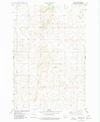
1975 Map of Wing SW
USGS Topo · Published 1977About this map
Rock Hill and the surrounding plains of Burleigh County define this mid-1970s landscape, characterized by a sparse settlement pattern of rural farmsteads and resource extraction. The map records a series of agricultural and industrial landmarks, including several Wells and multiple Gravel Pits used for local infrastructure. Union Cem stands as a quiet marker of the local community's history, situated near the center of the township. Drainage in the northern portion of the quadrangle is dominated by the East Branch Apple Creek, which meanders through the terrain. Civil divisions like Ghlyin and Cromwell delineate the administrative boundaries of the prairie, while Trygg marks another significant topographic feature. This survey provides a clear view of the rural landscape before late-century modernization, preserving the locations of fence lines and field boundaries as they existed during the 1974 aerial photogrammetric study.
Find a feature on this map
9 named features on this map. Tap any name to fly to it.
Don’t see what you’re looking for? This feature index may not catch every label — zoom into the map to look around manually.
Map Details
Editions of this 1975 Wing SW Map
This is the sole edition of this map. No revisions or reprints were ever made.
Other maps of this area

1907 · Bismarck
USGS Topo · 1:125,000

1951 · Menoken
USGS Topo · 1:62,500

1951 · McKenzie
USGS Topo · 1:62,500

1954 · Bismarck
USGS Topo · 1:250,000

1954 · McClusky
USGS Topo · 1:250,000

1958 · Bismarck
USGS Topo · 1:250,000

1958 · McClusky
USGS Topo · 1:250,000

1975 · Sibley Butte
USGS Topo · 1:24,000
1975 · Solberg Butte
USGS Topo · 1:24,000

1975 · Wing SE
USGS Topo · 1:24,000