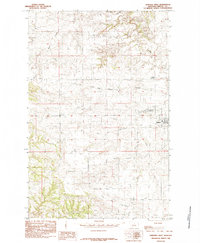
1985 Map of Winifred West
USGS Topo · Published 1985About this map
The prairie landscape of Fergus County is defined here by the town of Winifred, which serves as a central hub for the surrounding ranching and dry-land farming country. This 1985 provisional study reveals a terrain deeply incised by drainages such as Flax Coulee and Dog Creek, illustrating how the Missouri River watershed begins to carve into the Montana plains. The topography is marked by significant elevation changes, where high flats like those near Yaaps Corner drop away into the rugged draws of Sig Larson Coulee. Infrastructure in this era remained sparse, centered on the grid-patterned streets of Winifred and a handful of vital water management features like Stafford Reservoir. The map provides a clear look at the rural section lines and local roads that connected these isolated outposts before modern developments altered the agricultural footprint of the region.
Find a feature on this map
7 named features on this map. Tap any name to fly to it.
Don’t see what you’re looking for? This feature index may not catch every label — zoom into the map to look around manually.
Map Details
Editions of this 1985 Winifred West Map
This is the sole edition of this map. No revisions or reprints were ever made.
Other maps of this area

1954 · Taffy Ridge
USGS Topo · 1:24,000

1954 · Gallatin Rapids
USGS Topo · 1:24,000

1954 · Council Island
USGS Topo · 1:24,000

1954 · Lewistown
USGS Topo · 1:250,000

1959 · Lewistown
USGS Topo · 1:250,000

1964 · Anderson Bridge
USGS Topo · 1:24,000

1978 · Wild Bill Flat East
USGS Topo · 1:24,000

1978 · Lewistown
USGS Topo · 1:100,000
1985 · Hilger NW
USGS Topo · 1:24,000
1985 · Christina
USGS Topo · 1:24,000