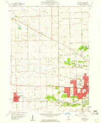
1959 Map of Winnebago
USGS Topo · Published 1960About this map
The western expansion of Rockford meets the rural agricultural landscape of Burritt and Winnebago townships in this late 1950s survey. The transition from urban streets to open country is marked by a network of public spaces, including Ingersoll Memorial Park and Page Park, while the local entertainment culture of the era is evidenced by the Drive-in Theater and prominent broadcast towers for Tower (WREX-TV) and Wtvo-TV. In the western portion of the sheet, the village of Winnebago sits along the Chicago and North Western railroad, serving as a focal point for the surrounding farms. Local history is well-preserved through numerous rural institutions like Burritt Center Sch and Stiles Sch, alongside several established burial grounds such as Willwood Cemetery and North Burritt Cem. The geography is defined by the winding paths of Kent Creek and Mud Creek, which cut through a terrain dotted with numerous quarries and gravel pits.
Find a feature on this map
58 named features on this map. Tap any name to fly to it.
Don’t see what you’re looking for? This feature index may not catch every label — zoom into the map to look around manually.
Map Details
Editions of this 1959 Winnebago Map
This is the sole edition of this map. No revisions or reprints were ever made.
Other maps of this area

1917 · Kings
USGS Topo · 1:62,500

1918 · Rockford
USGS Topo · 1:62,500

1918 · Kings
USGS Topo · 1:62,500

1922 · Oregon
USGS Topo · 1:62,500

1924 · Oregon
USGS Topo · 1:62,500

1932 · Pecatonica
USGS Topo · 1:62,500

1936 · Pecatonica
USGS Topo · 1:62,500

1938 · Rockford
USGS Topo · 1:62,500

1949 · Camp Grant
USGS Topo · 1:24,000

1949 · Rockford
USGS Topo · 1:24,000