1955 Map of Winnemucca
USGS Topo · Published 1974About this map
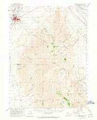
The Humboldt River corridor dictates the movement and settlement patterns of this Great Basin landscape, following the historic path of the Southern Pacific and Western Pacific railroads. These transit lines link a series of high-desert outposts including Winnemucca, Golconda, Battle Mountain, and Beowawe. The map illustrates the region's mid-century reliance on both ranching and extraction, with scattered operations such as the Iron Blossom Mine and Betty O'Neal Mine positioned against the massive backdrop of the Shoshone Range and Sonoma Range. Broad basins like Pumpernickel Valley and Whirlwind Valley separate the north-south running mountain chains, while notable water features like Buffalo Valley Hot Springs and Carico Lake provide critical resources in an otherwise arid environment. The inclusion of the Winnemucca Ind Res and Battle Mountain Indian Res further anchors the social geography of the era.
Find a feature on this map
65 named features on this map. Tap any name to fly to it.
Don’t see what you’re looking for? This feature index may not catch every label — zoom into the map to look around manually.
Map Details
Editions of this 1955 Winnemucca Map
3 editions found

Historical Maps of Winnemucca Through Time
5 maps found