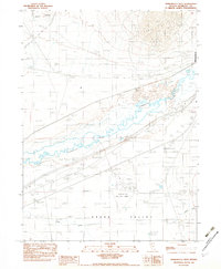
1982 Map of Winnemucca West
USGS Topo · Published 1982About this map
The Humboldt River carves a complex, braided path across this high desert landscape, defining the northern reaches of Grass Valley. This 1982 provisional edition captures the infrastructure supporting the region’s transportation and industry during the late twentieth century. In the southern portion of the map, the Winnemucca Municipal Airport serves as a significant landmark, featuring specialized aviation markers such as the Airway Beacon 32A and an Airport Dome.
Find a feature on this map
10 named features on this map. Tap any name to fly to it.
Don’t see what you’re looking for? This feature index may not catch every label — zoom into the map to look around manually.
Map Details
Editions of this 1982 Winnemucca West Map
This is the sole edition of this map. No revisions or reprints were ever made.
Other maps of this area

1882 · Paradise
USGS Topo · 1:250,000

1893 · Paradise
USGS Topo · 1:250,000

1932 · Sonoma Range
USGS Topo · 1:250,000

1939 · Sonoma Range
USGS Topo · 1:250,000

1955 · McDermitt
USGS Topo · 1:250,000

1955 · Winnemucca
USGS Topo · 1:250,000

1958 · Winnemucca
USGS Topo · 1:250,000

1958 · Winnemucca
USGS Topo · 1:62,500

1958 · Rose Creek
USGS Topo · 1:62,500

1959 · McDermitt
USGS Topo · 1:250,000