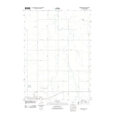
2012 Map of Winner North
USGS Topo · Published 2012About this map
The northern reaches of Winner, South Dakota, transition from a structured town grid into the expansive section lines of Tripp County. This landscape is defined by the northward flow of Thunder Cr and Sand Cr, which cut through the undulating prairie. The northern edge of the town is anchored by Winner Regional Airport, situated just above the residential streets like E Tripp Ave and Iowa St. In the northeast corner, the isolated landform of Bradleyon Butte stands as a prominent landmark above the surrounding fields. The map captures the interface between the local aviation hub and the rural township roads, such as Twp Rd, reflecting the transportation and agricultural layout of the early 21st century.
Find a feature on this map
32 named features on this map. Tap any name to fly to it.
Don’t see what you’re looking for? This feature index may not catch every label — zoom into the map to look around manually.
Map Details
Editions of this 2012 Winner North Map
This is the sole edition of this map. No revisions or reprints were ever made.
Other maps of this area

1955 · Mitchell
USGS Topo · 1:250,000

1959 · Mitchell
USGS Topo · 1:250,000

1971 · Colome
USGS Topo · 1:24,000

1971 · Hamill
USGS Topo · 1:24,000

1971 · Rattlesnake Butte West
USGS Topo · 1:24,000

1982 · King Dam
USGS Topo · 1:25,000

1982 · Winner North
USGS Topo · 1:25,000

1982 · Winner South
USGS Topo · 1:25,000
1982 · Miller Hill
USGS Topo · 1:25,000
1982 · Ideal
USGS Topo · 1:24,000