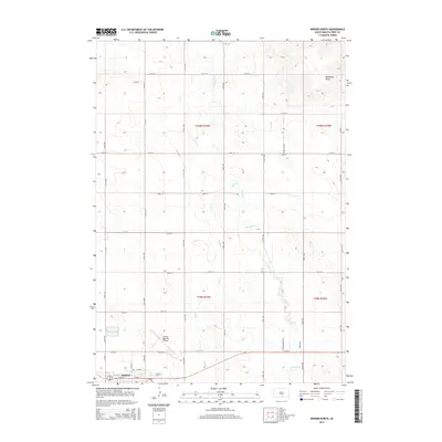
2015 Map of Winner North
USGS Topo · Published 2015About this map
The prairie landscape of Tripp County is defined here by the northern edge of Winner, where the local street grid meets the expansive section lines of the Great Plains. The Winner Regional Airport serves as a modern hub at the town's periphery, while the surrounding terrain is etched by the meandering courses of Thunder Cr and Sand Cr. These intermittent waterways cut through the high plains, punctuated by distinctive elevations like Bradleyon Butte in the northeast. The map provides a clear view of the rural transportation network, where named routes such as Stockland Ave, Thunder Creek Rd, and Parvin Rd follow the traditional townships and ranges. This layout reflects the enduring influence of the Public Land Survey System on the settlement patterns of South Dakota.
Find a feature on this map
37 named features on this map. Tap any name to fly to it.
Don’t see what you’re looking for? This feature index may not catch every label — zoom into the map to look around manually.
Map Details
Editions of this 2015 Winner North Map
This is the sole edition of this map. No revisions or reprints were ever made.
Other maps of this area

1955 · Mitchell
USGS Topo · 1:250,000

1959 · Mitchell
USGS Topo · 1:250,000

1971 · Colome
USGS Topo · 1:24,000

1971 · Hamill
USGS Topo · 1:24,000

1971 · Rattlesnake Butte West
USGS Topo · 1:24,000

1982 · King Dam
USGS Topo · 1:25,000

1982 · Winner North
USGS Topo · 1:25,000

1982 · Winner South
USGS Topo · 1:25,000
1982 · Miller Hill
USGS Topo · 1:25,000
1982 · Ideal
USGS Topo · 1:24,000