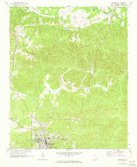
1969 Map of Winnsboro
USGS Topo · Published 1973About this map
The Southern railroad line serves as a central spine through this Fairfield County landscape, connecting the northern settlement of White Oak to the county seat at Winnsboro. The terrain is deeply etched by a network of waterways, including Big Wateree Creek, Little Wateree Creek, and Minton Creek, which create a complex system of ridges and valleys. This 1960s survey illustrates a rural community anchored by small churches and family burial grounds, such as Weeping Mary Ch, St Pauls Ch, and the Cason Cem.
Find a feature on this map
32 named features on this map. Tap any name to fly to it.
Don’t see what you’re looking for? This feature index may not catch every label — zoom into the map to look around manually.
Map Details
Editions of this 1969 Winnsboro Map
2 editions found
Other maps of this area

1904 · Columbia
USGS Topo · 1:125,000

1941 · Spartanburg
USGS Topo · 1:250,000

1942 · Camden
USGS Topo · 1:125,000

1953 · Spartanburg
USGS Topo · 1:250,000

1960 · Spartanburg
USGS Topo · 1:250,000

1963 · Spartanburg
USGS Topo · 1:250,000

1964 · Spartanburg
USGS Topo · 1:250,000

1968 · Blackstock
USGS Topo · 1:24,000
1969 · Great Falls
USGS Topo · 1:24,000

1969 · Lebanon
USGS Topo · 1:24,000