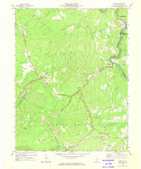
1969 Map of Winona
USGS Topo · Published 1973About this map
Nallen and Russellville anchor the northeastern landscape where the Meadow River carves through the terrain, marking the intersection of Fayette, Nicholas, and Greenbrier counties. This 1969 survey reveals a region deeply defined by coal extraction, with numerous Strip Mine operations and individual sites like the Lookout Mine and Air Shaft Mine dotting the ridges. The extraction economy is supported by the Chesapeake and Ohio railroad corridor following the river, while the local social fabric is preserved in landmarks such as the Old Stone House and several country churches including Bays Chapel and Chestnut Grove Ch.
Find a feature on this map
58 named features on this map. Tap any name to fly to it.
Don’t see what you’re looking for? This feature index may not catch every label — zoom into the map to look around manually.
Map Details
Editions of this 1969 Winona Map
2 editions found
Other maps of this area

1887 · Hinton
USGS Topo · 1:125,000

1889 · Nicholas
USGS Topo · 1:125,000

1891 · Nicholas
USGS Topo · 1:125,000

1891 · Raleigh
USGS Topo · 1:125,000

1892 · Hinton
USGS Topo · 1:125,000

1897 · Kanawha Falls
USGS Topo · 1:125,000

1897 · Raleigh
USGS Topo · 1:125,000

1900 · Kanawha Falls
USGS Topo · 1:125,000

1901 · Nicholas
USGS Topo · 1:125,000

1901 · Kanawha Falls
USGS Topo · 1:125,000