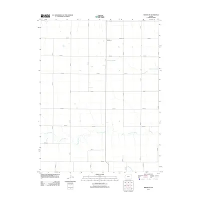
2012 Map of Winona NE
USGS Topo · Published 2012About this map
The High Plains landscape of Logan County is defined here by the winding headwaters of the Saline River system. The S Fork Saline River meanders across the southern half of the quadrangle, while the N Fork Saline River cuts through the northern section. These watercourses provided the essential orientation for the region's early development, though by the early 21st century, the area is primarily structured by a rigid section-line road grid, including Co Road A and Co Road I. A significant landmark for local history researchers is the Summers Township Cem, located in the north-central portion of the map. In the southeast corner, the drainage of N Br Hackberry Cr begins its descent, illustrating the subtle topographic shifts that dictate the flow of water across this Kansas prairie.
Find a feature on this map
23 named features on this map. Tap any name to fly to it.
Don’t see what you’re looking for? This feature index may not catch every label — zoom into the map to look around manually.
Map Details
Editions of this 2012 Winona NE Map
This is the sole edition of this map. No revisions or reprints were ever made.
Other maps of this area

1943 · Colby
USGS Topo · 1:62,500

1954 · Goodland
USGS Topo · 1:250,000

1956 · Goodland
USGS Topo · 1:250,000

1957 · Goodland
USGS Topo · 1:250,000

1967 · Colby SE
USGS Topo · 1:24,000

1967 · Colby SW
USGS Topo · 1:24,000

1972 · Monument
USGS Topo · 1:24,000
1972 · Winona
USGS Topo · 1:24,000

1972 · Winona NE
USGS Topo · 1:24,000
1972 · Winona NW
USGS Topo · 1:24,000