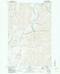
1981 Map of Winona
USGS Topo · Published 1981About this map
The settlement of Winona serves as a central hub in this Whitman County landscape, where the Union Pacific railroad tracks follow the winding course of the Palouse River. The map highlights a rural economy deeply tied to the land and transportation, evidenced by the clustered Grain Elevators, a Water Tank, and various Storage Bins near the tracks. To the west of the main settlement, the Winona Cemetery sits on a rise above the river valley.
Find a feature on this map
24 named features on this map. Tap any name to fly to it.
Don’t see what you’re looking for? This feature index may not catch every label — zoom into the map to look around manually.
Map Details
Editions of this 1981 Winona Map
This is the sole edition of this map. No revisions or reprints were ever made.
Other maps of this area

1950 · La Crosse
USGS Topo · 1:62,500

1950 · Endicott
USGS Topo · 1:62,500

1952 · La Crosse
USGS Topo · 1:62,500

1955 · Pullman
USGS Topo · 1:250,000

1955 · Spokane
USGS Topo · 1:250,000

1958 · Spokane
USGS Topo · 1:250,000

1958 · Pullman
USGS Topo · 1:250,000

1964 · Texas Lake
USGS Topo · 1:24,000

1964 · Revere
USGS Topo · 1:24,000

1964 · Ewan
USGS Topo · 1:24,000